

When I was younger, I enthusiastically conjured up my own worlds and entire games – a creative pursuit of passion that I still indulge in today.
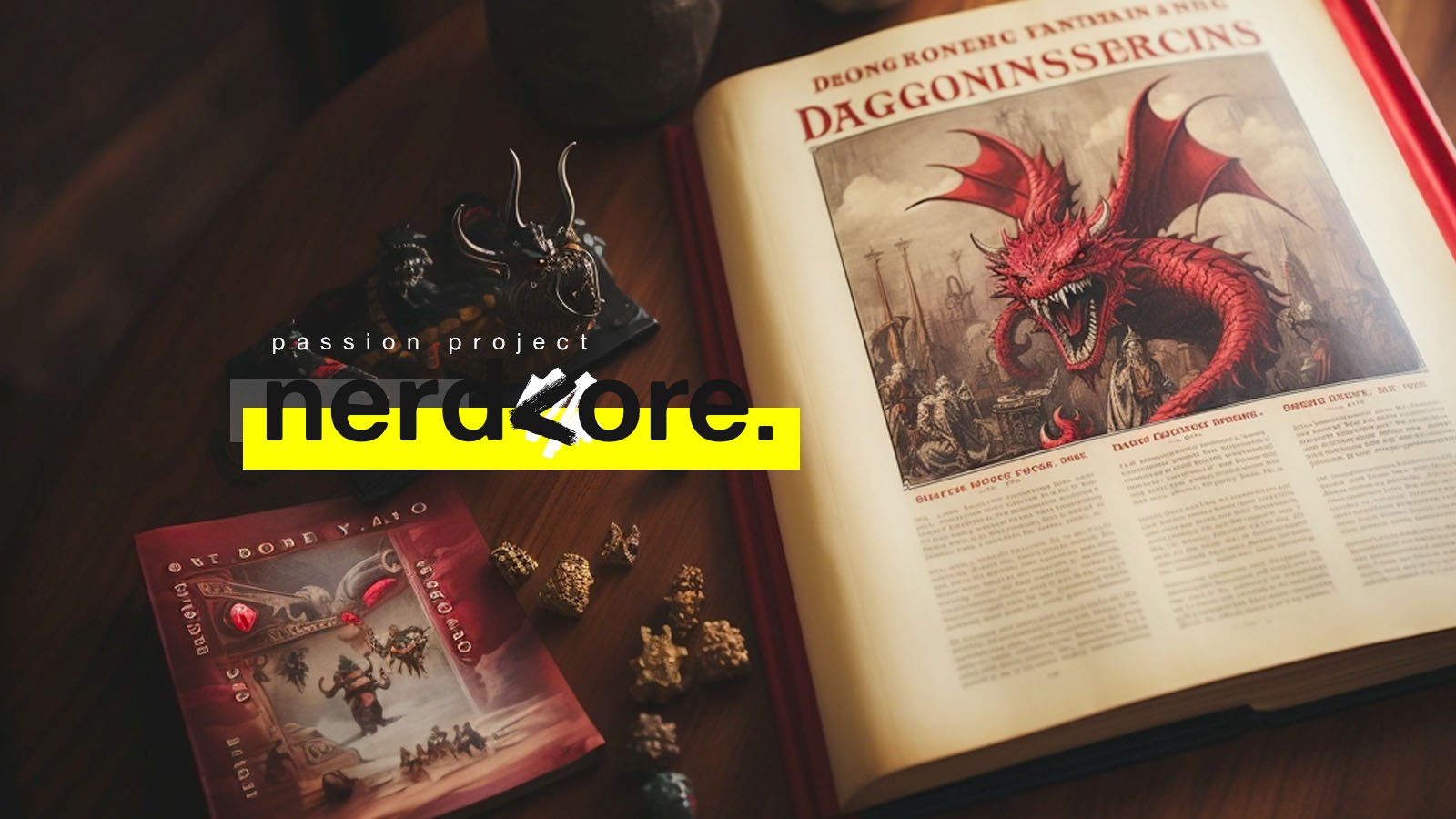
This is an adventure within the realm of my nerdiest hobby, as a dungeonmaster for "Dungeons & Dragons," where I began crafting my own unique world setting called “Düsterbruch”.

“The builder of worlds, spinner of fates
and creator of a thousand adventures.”
A brief excursion.

For those unfamiliar, let me quickly break down what Dungeons & Dragons is and why I was drawn to create my own world in this captivating game. Dungeons & Dragons, or D&D for short, is a tabletop roleplaying game (TTRPG) – essentially, it's a group improv-storytelling adventure. It seamlessly weaves together the art of improvisational theater, captivating storytelling, collaborative creative thinking and strategic battles. I am the "Dungeonmaster," the narrative architect, the builder of worlds, spinner of fates and creator of a thousand adventures. My role goes beyond just describing environments; I also orchestrate battles, outline magical effects, plan and navigate multiple evolving storylines. In essence, the Dungeonmaster oversees everything except the central characters – a role taken on by the players. While D&D offers numerous existing worlds and settings, where I've played both as a participant and a dungeonmaster, there has always been a lingering desire for a something uniquely my own – my own setting.
Developing one's own setting is fundamentally a crazy, multi-layered rabbit whole – like you have not seen. Whether it's Tolkien's Middle-earth, Martin's Westeros, or D&D's Forgotten Realms – they all have one thing in common: they feel alive and lived in. They are the home of rich and deep lore, multi-threaded storylines, historically inspired conflicts and intrigue ,and memorable characters and villains. Well, I'm no Tolkien, nor aspiring to become him. But, I am a multi-disciplinary creative thinker, that tends to work and think in a visually oriented manner, and there is another thing all the greats have in common: fantastic maps of their worlds. And it was precisely with a map that i wanted to start my creative process into this worldbuilding adventure. So, before I even conjured a single line of text or character, I spent hours giving my world a face – its own regional map. It all started within a simple flash-based hexmap editor – rudimentary, colorful hexagonal fields with simple icons representing mountains, fields, forests and settlements. I also added the first major cities in names only and a few POI to have locations for a few first adventures and sessions with my group. And somewhere in the middle of 2018, i introduced this version of my setting to a few of friends and started a homebrew campaign within my world. Good times, but certainly not the end of my worldbuilding project.
The general advice for worldbuilding suggests starting small and expanding later. Well, I took a different route. I began with a simple outline of a region and a basic concept. Even though my setting only had a map and a few names, I decided to kick off a new campaign for our bi-weekly D&D session, set right in my region. Yet, after a few sessions, a sense of something missing lingered – staring at the hexmap just didn't ignite any inspiration. To address this growing feeling, I did what anyone would do: I turned to Google. After a few search results and a deep dive into my bookshelf, I found the solution: I needed an illustrated version of it.
"Oh, I do love a map!"
— Mr. Bilbo BagginsOver a span of around three weeks, much to the puzzled amusement of my co-workers, I began utilizing my lunch breaks differently. Picture this: me at my desk, surrounded by multiple sheets of white paper and an array of ink pens, avidly delving into various cartography subreddits. My aim? To immerse myself in the techniques required to transform my hexmap into the style of a classic fantasy map, reminiscent of those found in books.
I may not be a professional illustrator, but I know my way around a pencil when the need arises. Thanks to countless hours of YouTube tutorials and style reference sheets, I successfully ushered my region into its second incarnation. Initially, I contemplated embracing a fully traditional approach, envisioning watercolors and Copix markers for that final touch. However, the grim reality of my lackluster hand-coloring skills quickly steered me towards a tool I'm much more acquainted with: Photoshop. So, after scanning, I digitally re-inked the outlines and hatchings before introducing colors and textures. To maintain the illusion of real paint, I employed various techniques and blend modes for emulation.
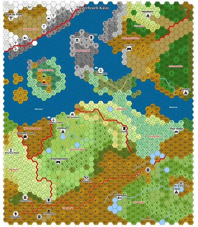
Now, the time had come to reintroduce my Points of Interest (POI) and settlements. Despite my attempts at illustrating heraldic shields and elements, even the best tutorials fell short of turning me into a proficient illustrator capable of achieving the level of detail I desired. Therefore, just as I did with Photoshop for coloring the map, I turned to another familiar tool: Illustator. There, i created my set of coat of arms for all the major settlements within my region, adhering to a cohesive design language. Each coat symbolizes a unique element or the name of the place, with the intention of aiding my players in navigation. (Minor spoiler: my players never caught onto this visual navigation hack. They just thought, "Cool coat bro." and just kept asking me "where is place X again?")


let’s do it again – from the ground up.
Following the title of this phase in the project, you can likely anticipate the ensuing events. Once again, several sessions transpired, and my players and I reveled in using the map for our campaign. New locations sprouted up, some even inspired by my players and surrounding landscapes got flashed out. Yet, as the details multiplied, updating the map became progressively challenging. The illustrative style, though aesthetically pleasing and distinctive, proved less adaptable to the ever-evolving landscape of information. So, armed with what I had created, I returned to Photoshop and Illustrator, but this time, I approached the map-making process quite differently.
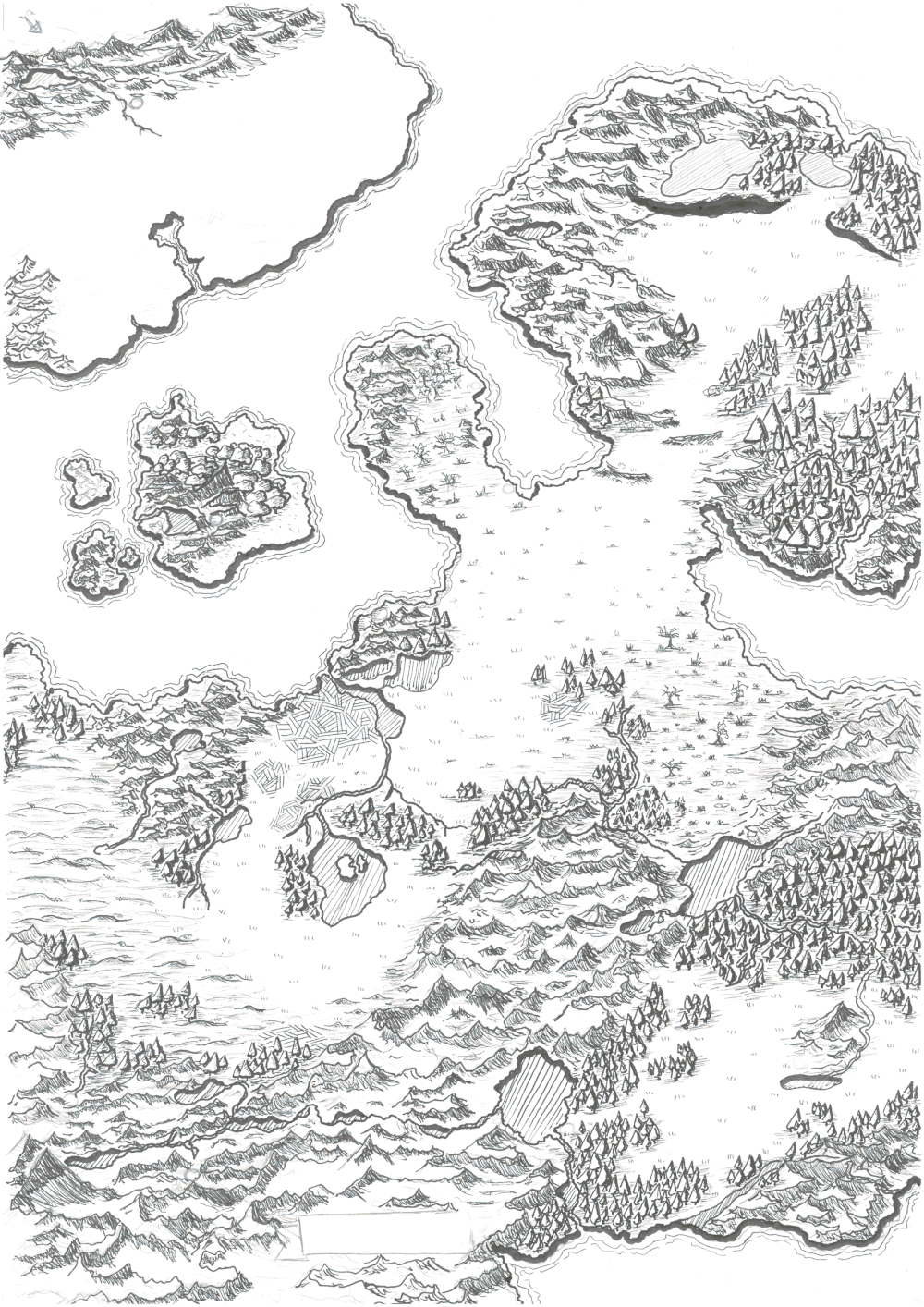
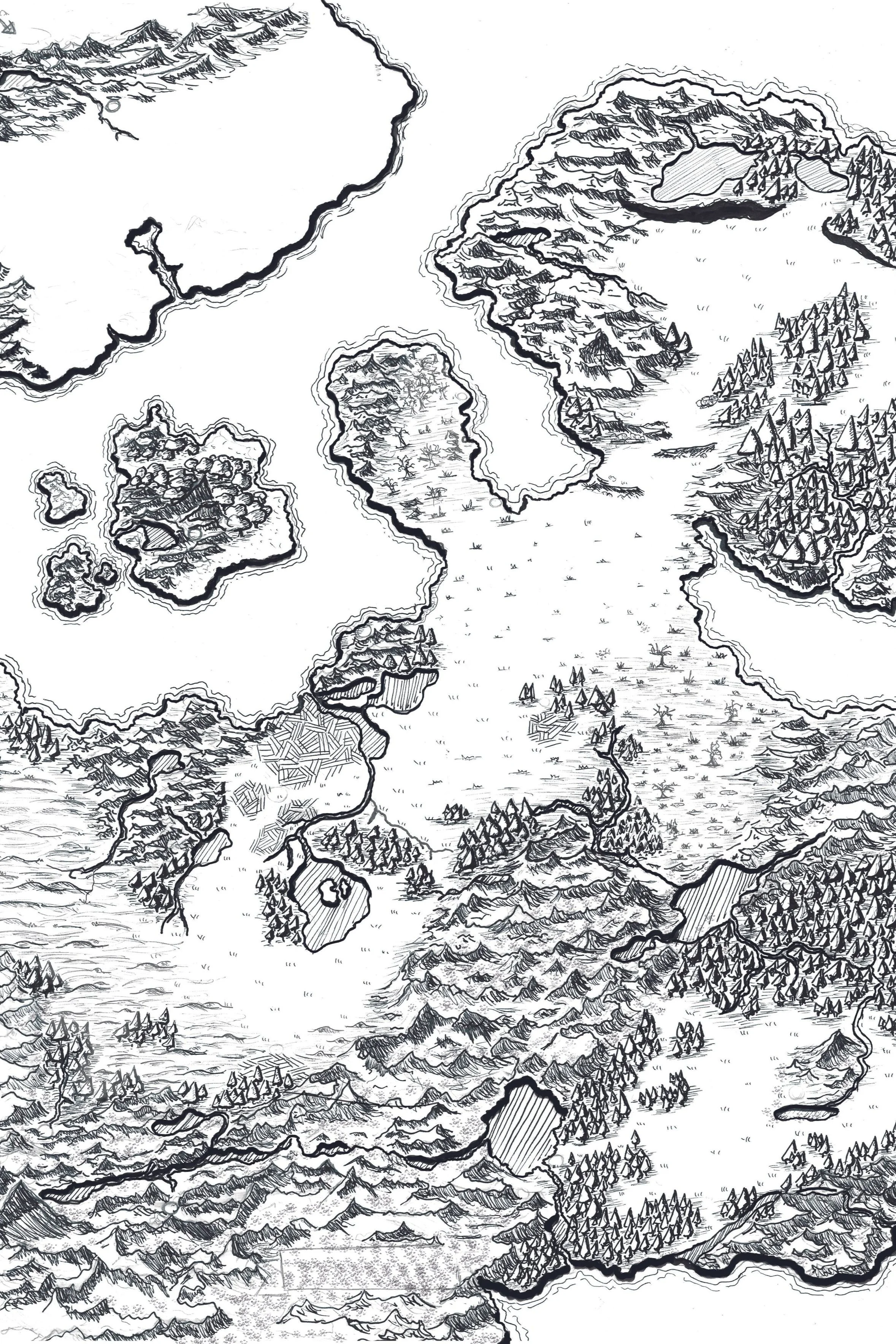
My prior foray into fantasy cartography led me to various subreddits dedicated to the niche craft of "map making", unveiling a wealth of pertinent information. This included insights into crafting a map that adheres to real-world principles governing the formation of mountains, the course of rivers, the development of wetlands, the growth of forests, and the interactions between different biomes. Equipped with this newfound knowledge and wielding two familiar tools, I embarked on the task of reconstructing my setting from the ground up. Landmasses underwent transformations, forests were relocated, and rivers found more natural courses through my fictional plains and hillsides. For a considerable stretch of this development, the map resembled more of an abstract painting. However, my vision for constructing the map was straightforward: a visual representation of elevation, ascending from low to high, across my region. It was at this moment that I realized my once simple hexmap had gradually evolved into a fully-fledged game map and as such, and by simple creative insanity, i indistinctively knew what i needed to do next: make it as real as possible.

"A picture is worth a thousand words. A satellite image is worth a million dollars."
— Sarah Parcakfive-hundred million dollars worth of layers.

Thanks to open source data, the seemingly insane idea of using real-world satellite images to realise my vision became a tangible reality. I dedicated a substantial chunk of my free-time scouring NASA's archives for the right kind of satellite image that aligned with the landscapes and biomes I had crafted in my mind. Building upon the contours of my previously created elevation map, I commenced the long process of texture kit-bashing. I pieced together a myriad of components, sourced from almost every region on Earth – a cliff from Norway, an beach from Japan, a river from Central Africa or an ice-capped mountain top from Antarctica. Nonetheless, given Earth's dense population, locating "untouched parts" proved quite the challenge.
So, to de-humanize the source images, I created a set of texture brushes to blend and reshape the satellite images itself. Multiple adjustment layers were used to further altered the images to match the climate zones and different biomes i needed.
In my vision, Düsterbruch has always been a setting heavily influenced by Eurocentric medieval times, deeply rooted in our own reality but sprinkled with fantastical elements like dragons, gods, and magic. So, it felt natural to tap into our own Earth as a resource to breathe life into my setting. Every typographic element underwent reediting and its own style, with additional Points of Interest (POI) thrown into the mix. Each part of my map underwent intensive editing and post-processing, culminating in a final Photoshop file boasting more than 4GB in size with over 500 individually named layers – a result of over 20 hours of uninterrupted editing and roughly 30 hours scavaging NASA's satellite archives. The only thing left untouched were the coat of arms, which now more than ever, harmonized perfectly with the new look and feel of this new version of my map. Scroll down to see for yourself.

there is more
there is more
I also wrote a compendium.

In my worldbuilding journey, the map was just one puzzle piece, and if you figured that's the whole deal, think twice.
Crafting a playable setting meant going way beyond just cartography. Like, a whole bunch beyond. So, I started my creative writing process – jotting down everything I believed would give it that unique touch. Starting by flashing out all the Points of interest that only existed in name only. Creating a mirrage of non-player-characters (NPCs) for all the different races, cultures and factions within my setting – all with different background and quirks and short descriptions. I created stylized city maps with their own POIs for the players to discover and interact with, and a series of POI-specific plothooks, that i as the dungeonmaster, can use if needed.

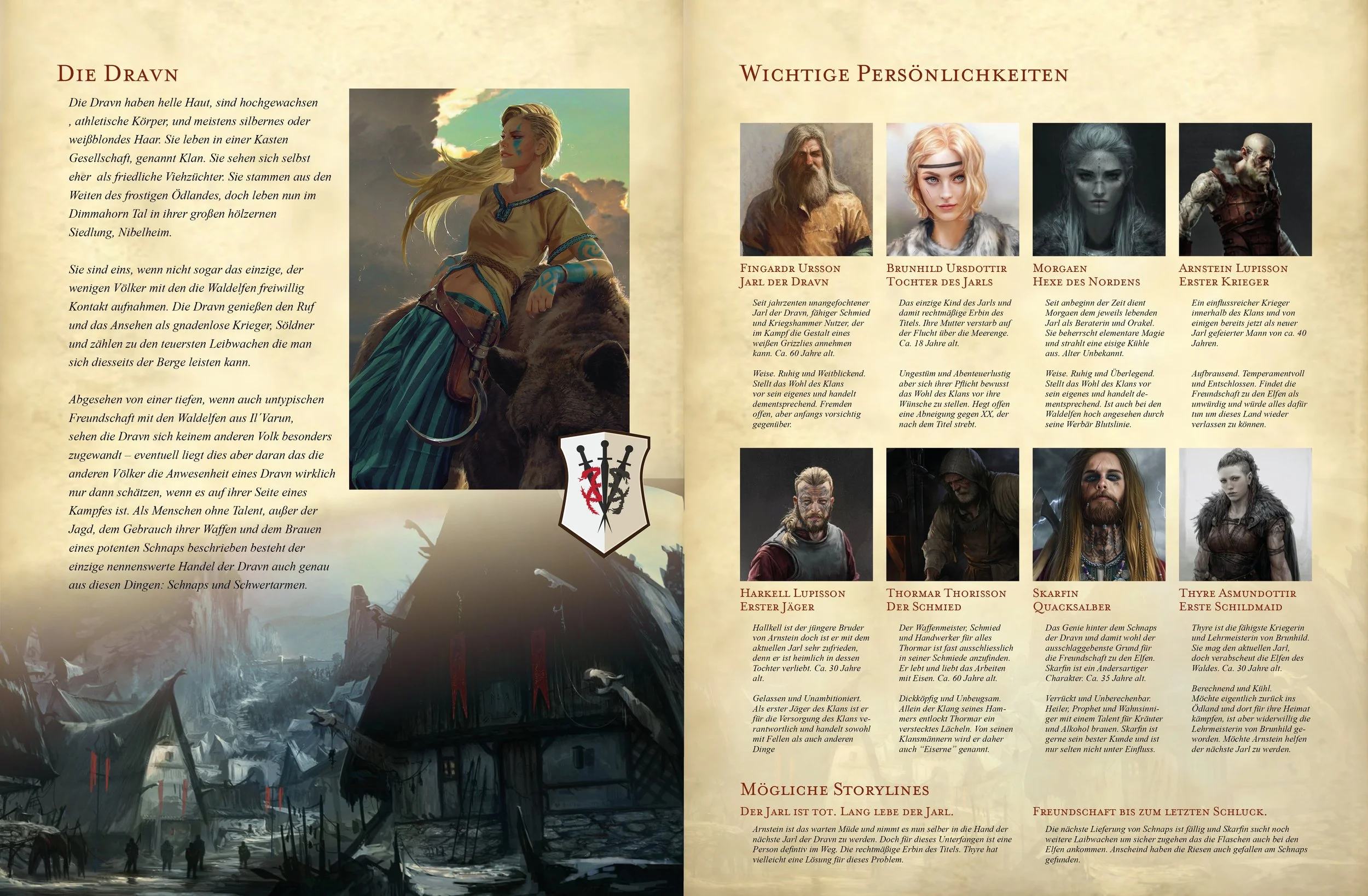
Additionally, i stared developing the regions own history through the ages and created different spreadsheets to track its fictional history, battles and ages. And before i forget – i also created my own pantheon, consisting of 9 greater gods and 9 minor, representing different aspects i deemed relevant within my setting. In the current companion book, everything is represented by visual aids found on the internet, created by talented artists from all over the world, . The issue i have with this is, these are artworks that were not created for this project – so the next logical step for me is to use AI-Tools, to rework and exchange all the images used right now, with my own creations. But, there is one minor problem – time.
It's been a long whole since I had a enough free time to dive into this project close to my heart. But I'm optimistic that, sooner or later, I'll carve out the time to wrap up the book, finish this project and savor that satisfying sense of completion. Maybe even turn to cinema4D and create a 3D version of my worldmap – just to have it.
My biggest dream though? To share and explore this world I've crafted with my most precious treasure: my son.
To host a family campaign with him, my wife and my brother as players experiencing adventures together. Slaying dragons, finding treasures and simply crafting stories he hopefully will cherish long after I am gone.